
A pair of earthquakes rattled Maryland, with dozens of people reporting to USGS they felt the Earth move. According to USGS, the first of the pair struck last night at 12:41 am. That earthquake had a depth of 6.2 km and was rated as a magnitude 2.1 event. The second earthquake struck just over 5 hours later at 5:54 am and struck from a depth of 5.0 km; it was rated a weaker magnitude 1.7 event. Both earthquakes struck near the town of Rising Sun, Maryland about 4 miles apart of each other; Rising Sun is just south of the state line with Pennsylvania to the north and about 12 miles west of the state line with Delaware.
According to USGS, earthquakes with a magnitude of 2.0 or less are rarely felt or heard by people, but once they exceed 2.0 , more and more people can feel them. While damage is possible with magnitude 3.0 events or greater, significant damage and casualties usually don’t occur until the magnitude of a seismic event rises to a 5.5 or greater rated event.
There hasn’t been much seismicity in the Mid Atlantic in recent weeks. According to USGS, the only other earthquake to strike within 250 km of today’s earthquake within the last three weeks was an even weaker magnitude 1.1 earthquake in Chester, New Jersey. The New Jersey earthquake was likely an aftershock from an April 2024 earthquake; the earthquakes in Maryland do not appear to be related to that series.
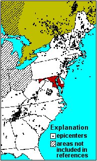
Maryland rarely experiences earthquakes but the volume has been increasing over time. According to USGS and the Maryland Emergency Management Agency, between 1758 and 1987 Maryland experienced 22 minor earthquakes. However, from January 1990 through December 1996, Maryland experienced 35 small tremors—1 in Harford County, 2 in Cecil County, 3 in Baltimore County, and 29 in Howard County. In only seven years, the number of known earthquakes in Maryland more than doubled.
The most recent significant event was on July 16, 2010, when a 3.6 magnitude earthquake occurred near Germantown. Ground shaking was felt as far away as Annapolis and Northern Virginia.
According to the Maryland Emergency Management Agency, based on available data, the overall earthquake risk to all jurisdictions, with the exception of Cecil County, is low to medium-low, relative to Maryland. Cecil County is ranked as medium primarily driven by population vulnerability, density and geographic extent. Frederick, Montgomery, Prince George’s, Charles, Calvert, Anne Arundel, Baltimore and Wicomico counties and Baltimore City are ranked medium-low based primarily on population density and population vulnerability.
Several earthquakes in adjacent states have been felt in Maryland but Marylanders are more likely to feel one of these out-of-state earthquakes than one within Maryland. Southwestern Virginia, central Virginia, and the Atlantic seaboard northward from Wilmington, Delaware have significantly more seismic activity than does Maryland. One out-of-state earthquake that was felt in much of Maryland occurred Easter Sunday, April 22, 1984. In fact, it was reported felt in eight states and the District of Columbia, over an area of approximately 19,000 square miles. Centered about 12 miles south of Lancaster, Pennsylvania, this earthquake was measured as a 4.1 magnitude seismic event. According to the Maryland Geological Survey, most notable effects in Maryland were in the northeastern part of the state. The Lancaster earthquake is likely related to Triassic-age structures in the area.
