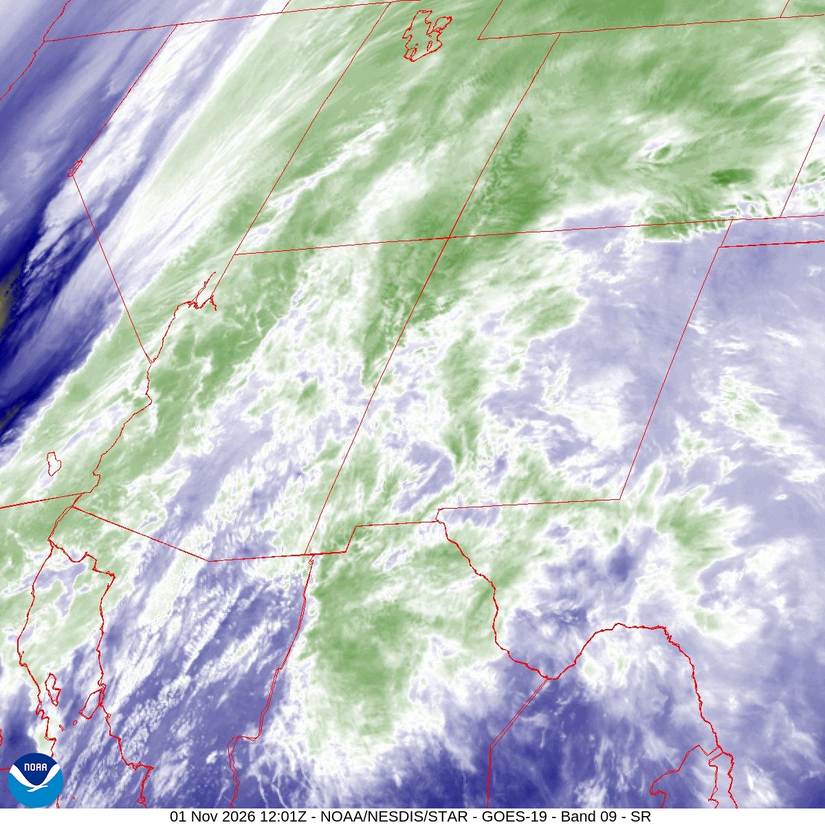
A plume of tropical moisture from near Hawaii, which meteorologists call a “pineapple express,” soaked Arizona and the Four Corners over the weekend. The rain flooded an estimated 150 to 200 homes in the Rimrock and Lake Montezuma area, forced evacuations from Sedona to southwestern Colorado and pushed rivers to record levels that forecasters said would take days to fall.
The rain ended early Monday. Forecasters at the National Weather Service in Flagstaff said radar and rain gauges showed a widespread 2 to 5 inches, and locally more, had fallen since Sunday across and south of the Mogollon Rim, with “some stream gauges exceeding record stage heights.”
“This continues to be a serious situation for areal and river flooding, despite a dry forecast for the next several days,” forecasters wrote in their Monday morning discussion. “Stay away from waterways, and if you come to a flooded road, turn around, don’t drown.”
The weather service office in Phoenix said three days of measured rain and radar estimates showed 5 to 7 inches across a large area of higher terrain east and northeast of the city, with a few spots reaching 8 inches. Crown King, in the Bradshaw Mountains, recorded 6.21 inches, according to weather.com.
Record Crest on the Little Colorado
One of the most serious threats Monday was in Winslow. The Flagstaff office said a record flood stage was observed early Monday on the Little Colorado River at Winslow, “with the levee expected to be overtopped within the next several hours.”
The river stood at 23.05 feet at 1 a.m. Monday, well above its 19-foot flood stage, and a crest over 40 feet was possible by 1 p.m. Tuesday, according to a flash flood warning issued at 2:06 a.m. The weather service said that at 25 feet the levee is overtopped, bringing major flooding to parts of Winslow including the Ames Acres and Bushman Acres neighborhoods.
Elsewhere, Burro Creek at U.S. 93 in northwestern Arizona rose to 17.9 feet, which the weather service called “a record crest level.”
Sedona and the Verde Valley
Some of the worst flooding struck the Verde Valley, where Oak Creek, Wet Beaver Creek and West Clear Creek feed the Verde River.
Sedona moved some areas along Oak Creek to “Set” status at 7:15 a.m. Sunday and raised them to “Go” at 7:45 a.m., the Sedona Red Rock News reported. The orders covered zones 8, 9 and 10 on the city’s east side, including properties next to the creek. At least 19 homes were evacuated, and some had 3 to 4 inches of water inside, Yavapai County spokesman David S. McAtee told AZFamily. Firefighters called in extra crews for what the station described as an “excessive amount” of water rescues.
Downstream, Oak Creek at Cornville was at 16.93 feet at 8 p.m. Sunday, more than double its 8-foot flood stage, the weather service said.
Jenny Kittredge, who manages Forest Houses Resort in Oak Creek Canyon, told KNAU the creek was “this really dark brown churning river, and it’s moving really quickly.”
“It was the highest I have ever seen it in my 33 years here,” she said.
The Flagstaff office said emergency managers reported at 8:28 p.m. Sunday that 150 to 200 homes had been affected by flooding along Wet Beaver Creek in the Lake Montezuma and Rimrock areas.
In Camp Verde, the Marshal’s Office ordered residents near the Verde River, West Clear Creek and Wet Beaver Creek to evacuate immediately and opened a temporary shelter at the town’s parks and recreation gym.
Verde Valley Fire Chief Danny Johnson told 12News that crews went house to house and carried out at least a dozen swift-water rescues Sunday. He said a couple thousand homes were in jeopardy of flooding.
“We’re seeing record flows on every flood gauge that’s coming into the rivers that feed into the Verde,” Johnson said.
The Verde River near Clarkdale and near Camp Verde remained above major flood stage early Monday, and emergency management reported evacuations along the river, the weather service said. The Camp Verde gauge read 23.51 feet at 11 p.m. Sunday, against a flood stage of 17 feet.
Horrible scenes around Arizona:
— the Weatherboy (@theWeatherboy) November 2, 2026
Water Rushes Toward Phoenix
Runoff from the mountains poured into the reservoirs that serve the Phoenix area. Around 3 a.m. Monday, Salt River Project was releasing more than 60,000 cubic feet per second from Bartlett Dam into the Verde River and more than 34,000 cubic feet per second from Granite Reef Dam into the Salt River, the Phoenix office said.
“Recreating in the Verde and Salt rivers will be very dangerous and is strongly discouraged,” forecasters wrote. “There have been multiple fatalities from recreation with similar flows in the past.”
A weather service warning said the Salt River near Roosevelt had risen above its flood of record, peaking at 30.6 feet in the 24 hours ending at 1:30 a.m. Monday. The previous record was 30.1 feet on Jan. 8, 1993.
In Flagstaff, city officials discouraged driving Sunday because emergency crews were operating at capacity, KNAU reported.
Four Corners Flooding
The flooding reached well beyond Arizona. Weather.com reported 3.77 inches at Lava Point, Utah, 2.98 inches at Sandoval, Colorado, and 2.09 inches at Albino Canyon, New Mexico.
In southwestern Colorado, the San Juan River at Pagosa Springs was in major flood. The river reached 16.81 feet at 8 p.m. Sunday, The Colorado Sun reported, and NOAA river data showed 16.03 feet at 9:45 p.m. That is close to the 17.8-foot crest of Oct. 5, 1911, the river’s record, and an earlier forecast had called for a crest above it.
More than 1,000 homes were under mandatory evacuation orders in Archuleta County, many of them also evacuated during the previous week’s storm, Sheriff Mike Le Roux told the Sun. The town of Pagosa Springs also warned that sewage was being discharged into the San Juan River and urged people to stay away from the water, Fox Weather reported.
Highways were cut off across the region. U.S. 64 was closed in both directions near Chama, New Mexico, because of flooding, and U.S. 70 was closed at the Arizona-New Mexico line, according to weather.com. In Utah, a landslide near the Monticello airport closed U.S. 191 after the Utah Department of Transportation reported debris and flooding on the road.
A Second Blow in Just Over a Week
The storm struck just over a week after flooding hit parts of Arizona, Nevada, New Mexico and Utah, and the ground was still saturated from 2 to 5 inches of rain that fell then, weather.com said.
Tribal communities on the Hopi and Navajo reservations again dealt with washed-out roads and flooded homes, KNAU reported. The station said the San Juan River at Shiprock, New Mexico, on the Navajo Nation was expected to rise from Monday afternoon through Tuesday.
Weather.com meteorologists said the atmospheric river was not especially strong but arrived earlier than usual, possibly a sign of things to come because the Southwest tends to be wetter during strong El Niño years.
What Comes Next
Drier air moved in behind a cold front Monday. Both the Flagstaff and Phoenix offices said there is little or no chance of rain over the next several days.
Even so, the Flagstaff office said river flooding could continue into at least Wednesday. The Phoenix office said the Salt and Verde systems could stay high for most of the week.
The storm system moved east of the Rockies on Monday, where it was expected to bring severe thunderstorms to the Plains.
