Image: National Weather Service Sacramento
A Pacific storm moving toward Northern California and southern Oregon is expected to bring heavy, wet mountain snow, damaging wind gusts and breaking waves as high as 35 feet starting Friday, prompting the National Weather Service to issue winter storm warnings for the Sierra Nevada and high surf warnings along much of the coast from Oregon to Big Sur.
The weather service’s Sacramento office said Thursday that “a series of storm systems will bring widespread rain, moderate to heavy rain and snow in the mountains, and gusty to strong southerly winds Friday into early next week.”
ABC7 meteorologist Drew Tuma said the system had been upgraded to a Level 2 storm on the station’s scale, the first moderate storm of the season for the San Francisco Bay Area, and that it was expected to bring an end to the region’s fire season.
Heavy Snow and Strong Wind in the Sierra
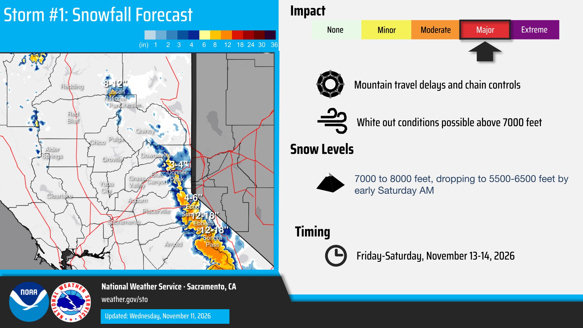
A winter storm warning issued by the Sacramento office runs from 10 a.m. Friday to 10 a.m. Saturday for the northern Sierra above 6,000 feet, including Interstate 80, U.S. Highway 50, State Route 4 and State Route 108, and for the southern Cascades, including Lassen Volcanic National Park. Forecasters said snow totals could reach a foot, with up to 2 feet on the highest peaks, and winds could gust as high as 60 mph.
“Travel could be very difficult,” the warning said, adding that strong winds could cause downed tree branches, localized power outages and near-whiteout conditions. Snow levels are forecast to start between 6,500 and 7,500 feet Friday before dropping to between 5,500 and 6,500 feet Saturday morning, with the heaviest snow expected Friday night into Saturday morning.
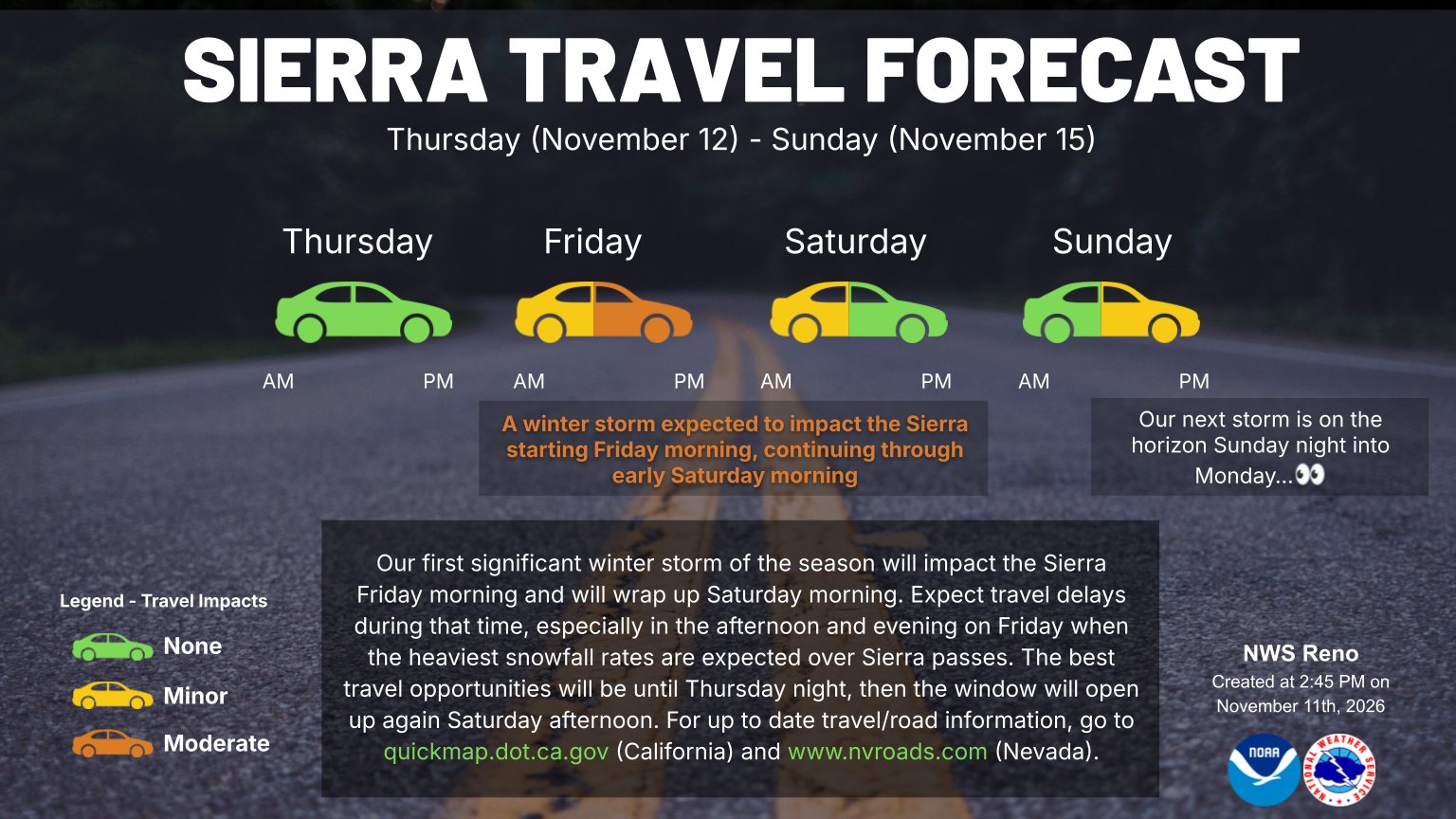
Image: National Weather Service Reno
Around Lake Tahoe, the weather service office in Reno, Nevada, upgraded an earlier watch to a winter storm warning, also running from 10 a.m. Friday to 10 a.m. Saturday. The Reno office forecast about 12 inches of heavy, wet snow above 7,000 feet, up to 6 inches below that elevation and as much as 20 inches along the crest west of the lake. Ridge-top gusts could reach 70 to 90 mph, with gusts of 35 to 45 mph in Truckee and lakeside communities and waves of 2 to 4 feet on Lake Tahoe.
“Strong winds and Sierra cement snow could cause damage to trees and power lines,” the Reno office said, using a local term for the dense, wet snow common in the range.
In Mono County, a separate warning calls for 1 to 2 feet of snow above 7,000 feet, gusts of 60 to 80 mph over ridges and 45 to 55 mph along U.S. Highway 395 from 1 p.m. Friday to 10 a.m. Saturday. The Reno office said in its forecast discussion that the heaviest snowfall rates late Friday night into early Saturday could exceed 2 inches an hour at times.
“If you’re planning to travel around the Sierra, consider postponing until the bulk of the system has passed,” the office said, pointing drivers to Caltrans QuickMap and NVRoads for chain controls and closures.
Farther south, the Las Vegas office issued a winter storm warning for the eastern Sierra slopes of Inyo County, and the Hanford office posted a winter storm watch for the Sierra above 6,000 feet, including Yosemite, Kings Canyon and Sequoia national parks, from Friday afternoon through late Monday night, with 6 to 12 inches possible and gusts up to 50 mph.
Dangerous Surf From Oregon to Big Sur
Along the coast, a powerful swell is expected to build quickly. The weather service office in Eureka, California, issued a high surf warning for breaking waves of 30 to 35 feet along coastal Del Norte and northern Humboldt counties from 1 p.m. Friday to 4 a.m. Sunday, and for southwestern Humboldt and coastal Mendocino counties starting at 4 p.m. Friday.
“Breaking waves can sweep people off jetties and docks, and into dangerous seas,” the Eureka office said, warning of “life-threatening surf conditions and significant beach erosion.” The office said a second large swell is forecast late Sunday through Monday after only a brief improvement.
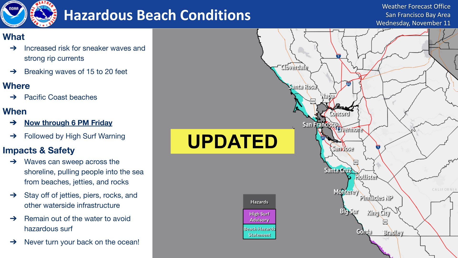
Image: National Weather Service San Francisco Bay Area/Monterey
On the southern Oregon coast, the Medford office forecast breaking waves of 20 to 25 feet Friday, increasing to 30 to 35 feet late Friday through Saturday, from Charleston to Port Orford, Gold Beach and Brookings. “Waves will inundate beaches and surge into normally dry areas,” the warning said, adding that infrastructure damage and significant beach erosion can be expected.
The same stretch of Oregon coast is under a high wind warning from 10 p.m. Thursday to 10 a.m. Friday, with south winds of 25 to 40 mph and gusts up to 65 mph near headlands. “Widespread power outages are expected,” the Medford office said. Inland, a high wind warning in the Shasta Valley of Siskiyou County, including Weed and a stretch of Interstate 5, calls for gusts up to 70 mph.
In the Bay Area, the weather service moved up a beach hazards statement because rough seas arrived earlier than expected, with breaking waves of 15 to 20 feet possible through Friday afternoon. A high surf warning follows from 6 p.m. Friday to 4 a.m. Sunday for the coastal North Bay, including Point Reyes National Seashore, the San Francisco Peninsula coast and northern Monterey Bay, with breaking waves of 25 to 35 feet and “occasional sets of 40 to 50 ft at favored breakpoints.”
Coastal flood advisories for San Francisco and the southern Monterey Bay and Big Sur coast warn that up to 1.5 feet of inundation is possible in low-lying areas near shorelines through Friday afternoon, and that large waves could crash over seawalls Saturday.
Surfers in Pacifica told ABC7 the swell was already building. “It could look flat. It could look calm. And then all of a sudden, here comes 3 or 4 giant waves, and they push way up high on shore,” surfer Craig Garza told the station.
Farther south, the Los Angeles office issued a coastal flood watch for San Luis Obispo County beaches and the Santa Barbara County Central Coast from late Friday night through Saturday afternoon, saying waves of 18 to 25 feet are possible on exposed beaches and that there is “a moderate risk of damaging flooding of sea water” in vulnerable low-lying areas.
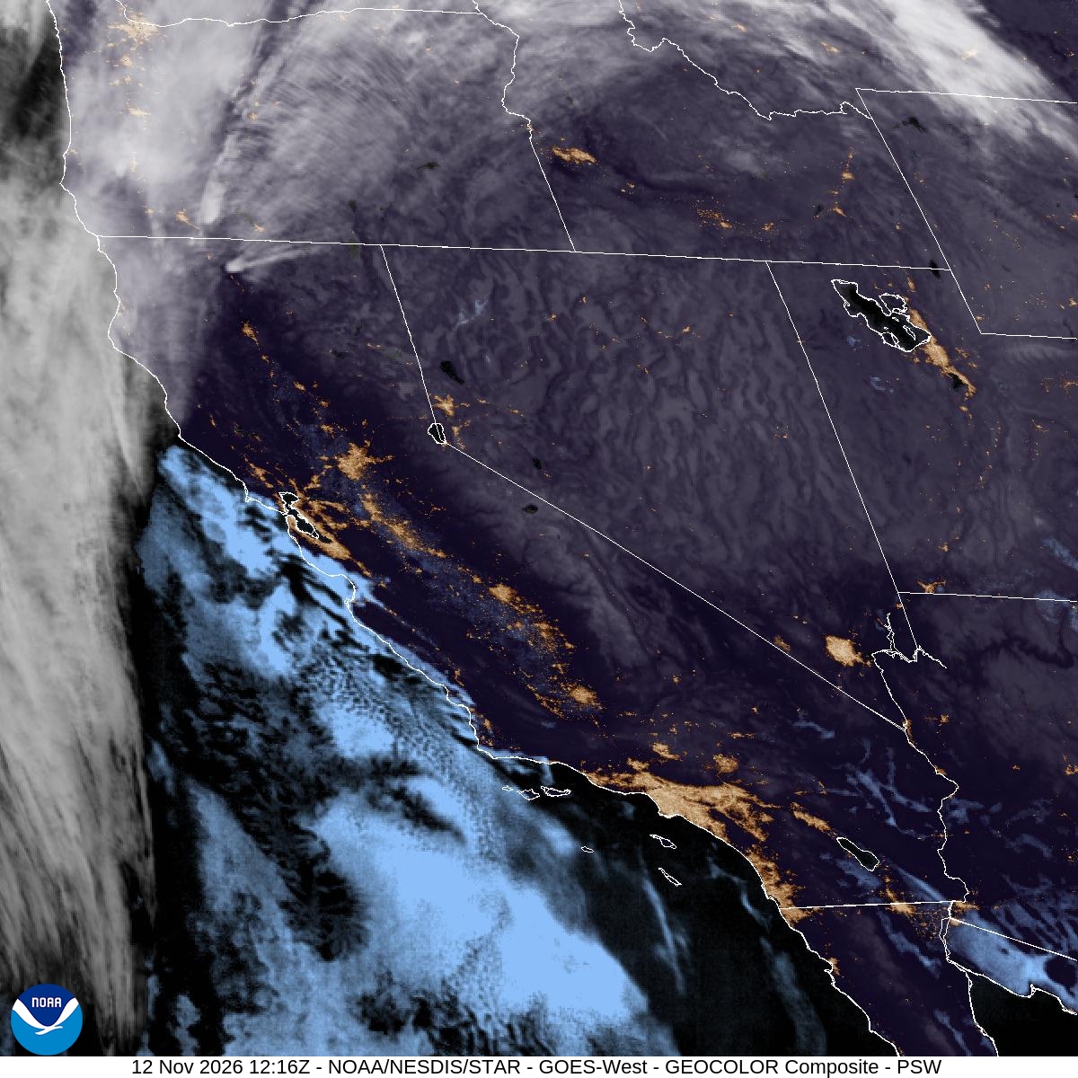
Image: NOAA/NESDIS/STAR, GOES-West
Rain and Wind in the Valleys
In the Sacramento Valley, forecasters expect 0.25 inch to 1 inch of rain, with up to 2 inches in the mountains and foothills and locally more under thunderstorms Friday afternoon and evening. A wind advisory covers Solano County, including Fairfield, Vacaville and Vallejo, from 4 a.m. to 7 p.m. Friday, with gusts up to 40 mph.
Tuma said most Bay Area cities should receive about half an inch of rain, with up to 1.5 inches or more in the North Bay and Santa Cruz Mountains, and wind gusts of 30 to 50 mph. He said the heaviest rain and strongest winds were expected from 10 a.m. to 2 p.m. Friday.
What Comes Next
The Reno office said the first storm should wrap up by daybreak Saturday, though slick roads could linger through late morning. Saturday afternoon through much of Sunday should be dry before a colder but weaker system arrives late Sunday night into Monday, with up to 5 inches of snow along the crest and slushy roads possible for the Monday morning commute. Another storm may follow Wednesday into Thursday, the office said.
NWS Reno said the best windows for crossing the Sierra this weekend are through Thursday night and again from Saturday afternoon through Sunday afternoon.
