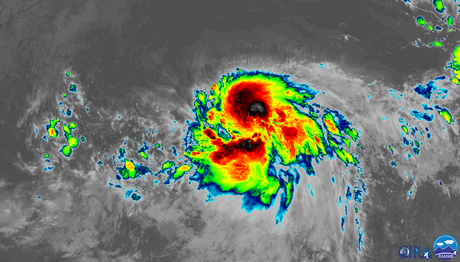
Tropical Storm Barbara continues to gain strength. The National Hurricane Center (NHC) believes it will reach hurricane status later today and could become a major hurricane by tomorrow night with maximum sustained winds of 125mph. Barbara is the first tropical storm of the 2018 Eastern Pacific Hurricane Season; it could become the second hurricane, after Alvin, and could become the first major hurricane of the young season. Computer forecast guidance continues to suggest that Barbara could impact Hawaii directly or indirectly in some form after the Fourth of July.
According to the NHC this morning, although earlier microwave imagery indicated that Barbara was still being affected by moderate northwesterly shear, the upper-level outflow expanded overnight and the center appears to be more embedded within the area of very cold cloud tops. Due to analysis of data and imagery from the storm, the NHC increased the intensity of this system to 63mph. Once maximum sustained winds reach 74 mph, the system will become a hurricane. When hurricanes have maximum sustained winds of 125 mph or greater, they are considered “major hurricanes” due to the major damage they can create.
The global computer forecast models continue to forecast a reduction in the deep-layer vertical wind shear during the next couple of days while Barbara moves over warm sea surface temperatures. These conditions are expected to allow steady to perhaps rapid strengthening over the next couple of days. The NHC forecast is predicting significant strengthening during the next 24 to 48 hours. However, after 72 hours, cooler waters and increasing southwesterly shear are expected to cause gradual weakening. A deep-layer ridge to the north of the storm is forecast to gradually weaken over the next several days, allowing for Barbara to slow down and turn west-northwestward within the next day or so. In about 4 days, the ridge is forecasting to build westward which should cause the tropical cyclone to turn back toward the west. While the dynamical models generally agree on the overall scenario there are some differences in the predicted forward speed and how far north Barbara will move. The American GFS and European ECMWF models both bring Barbara to Hawaii in some fashion. The American GFS suggests a more northerly approach to the islands, which would bring it over colder waters. For now, it tracks a weakening, decomposing system into Hawaii around July 9 or 10. Even as a weak system, Barbara could dump extremely heavy, flash-flood generating rains on the state. The European ECWMF is a bit more ominous; because it tracks the system more south than the American model, it maintains its intensity as it approaches the Aloha State. As a result, it has a tropical storm force or greater system impacting the Big Island around the same time as the GFS does. Such a solution would bring the potential for damaging winds in addition to soaking rains to the state.
It is important to point out that extended forecast guidance, especially with tropical cyclones, is prone to error, some of which could be significant. Errors with regards to track and intensity of hurricanes and other tropical cyclones are often substantial, especially more than a week away.
Nevertheless, officials in Hawaii want residents and visitors to be prepared just in case. Last week, Hawaii County Civil Defense hosted a Disaster Preparedness Fair. There, they stressed the need for people to have at least two weeks worth of supplies at anytime. With the threat of Barbara in the extended forecast, it serves as a reminder that the best time to prepare for a storm is well before any threat materializes.
Hawaii sits in the Central Pacific Hurricane Basin. Storm systems will enter the basin from the Eastern Pacific; when they do, the Central Pacific Hurricane Center takes over forecasting responsibility from the National Hurricane Center. The Central Pacific Hurricane Center is calling for an above normal season which runs from June 1 through to the end of November.
NOAA’s Central Pacific Hurricane Center (CPHC) Director, Chris Brenchley, described to us today how his Honolulu team coordinates, collaborates, & even swaps staff with Miami-based National Hurricane Center (NHC) to keep America #HurricaneStrong?@NWSHonolulu pic.twitter.com/W1WM2EeXeC
— the Weatherboy (@theWeatherboy) May 23, 2019