Tropical Storm Eta is racing through Florida and is forecast to clear the east coast soon. While Eta is wrapping up its impacts over the Sunshine State, it appears what’ll likely become Tropical Storm Iota is forming in the Caribbean Sea.
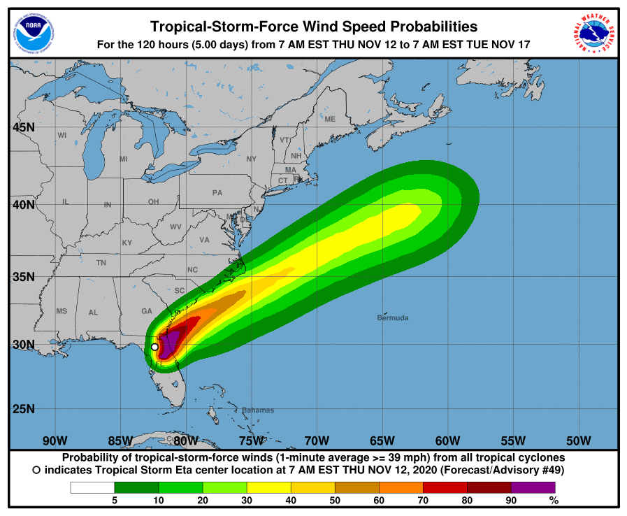
While Eta is a fraction of its former self, it is still producing heavy rains and gusty winds over portions of northeastern Florida and southeastern Georgia today. As of the latest advisory from the National Hurricane Center, it was about 15 miles southwest of Jacksonville, Florida with maximum sustained winds of only 45 mph. For the current conditions, a Tropical Storm Warning remains up from the Flagler/Volusia County line in Florida north to St. Andrews Sound in Georgia.
According to the National Hurricane Center, little change in strength is forecast through early Friday. Eta could re-intensify as a non-tropical cyclone late Friday or Friday night before becoming absorbed by a larger non-tropical cyclone on Saturday. Such a transformation would occur off-shore and not directly impact the U.S. or any landmass.
Eta will produce an additional 1-3″ inches of rain across portions of the Florida Peninsula through today, with isolated maximum storm total accumulations of 20-25″ in South Florida. Localized flash and urban flooding will be possible across the Florida Peninsula today, especially across previously inundated areas. Minor river flooding is expected across portions of West Florida lasting into the weekend.
Tropical storm force winds are expected to lash the Florida east coast through early this afternoon; by this evening, all tropical storm conditions should be wrapped-up state-wide. While the winds will fade, rough surf will linger. Swells generated by Eta are expected to affect the Florida Gulf Coast today, and begin to affect portions of the coast of the southeastern United States later today. These swells are likely to cause life-threatening surf and rip current conditions for the next few days. Even expert swimmers and surfers should avoid the ocean until calmer conditions return.
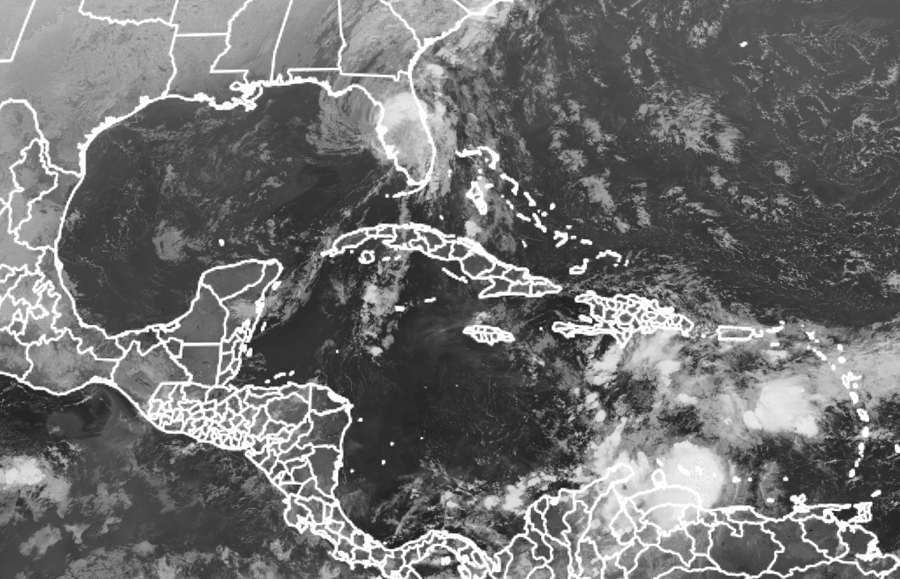
While Eta spins about over northeast Florida, a new system appears to be taking shape in the Caribbean. The National Hurricane Center now says there’s an 80% chance that a tropical cyclone will form here over the next 48 hours or a 90% chance that one will form over the next 5 days. The area of concern is a tropical wave located over the central Caribbean Sea. Today, it continues to produce a large area of showers and thunderstorms. Satellite imagery indicates that the disturbance is gradually becoming better organized, and according the the National Hurricane Center, a tropical depression will likely form within the next couple of days as it moves slowly westward over the central and western Caribbean Sea. Computer forecast guidance is also suggesting that it’ll become a tropical storm or hurricane over time; if it reaches tropical storm strength, it would be named Iota.
Regardless of development, this new system is expected to bring heavy rainfall along with possible flash flooding to portions of Hispaniola over the next day or so. People in Central America, especially those recently hit hard by Hurricane Eta, should closely monitor the future progress of this new system.
