The National Hurricane Center (NHC) in Miami, Florida is monitoring several disturbances in the basins they monitor for potential tropical cyclone development. The Atlantic has been quiet lately and continues to be relatively quiet, with just one area of concern. The Eastern Pacific has become very busy though, although no storms pose an immediate threat to land there.
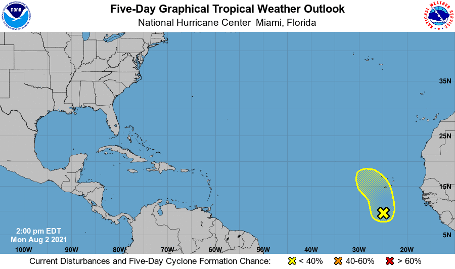
With the peak of the Atlantic Hurricane Season just over a month away, it is likely conditions will become more favorable for tropical cyclone development there. The presence of strong upper level winds and dry, dusty air has inhibited much development lately. However, today, the NHC says they are monitoring one area in the far eastern Atlantic for signs of possible development.
The NHC says a surface trough of low pressure over the Atlantic a few hundred miles south of the Cabo Verde Islands is producing disorganized showers and storms. Some development of this system is possible this week as it moves north and northwest. However, the NHC says odds of tropical cyclone development are low: only a 10% chance through the next 48 hours, and only a 20% chance over the next five days.
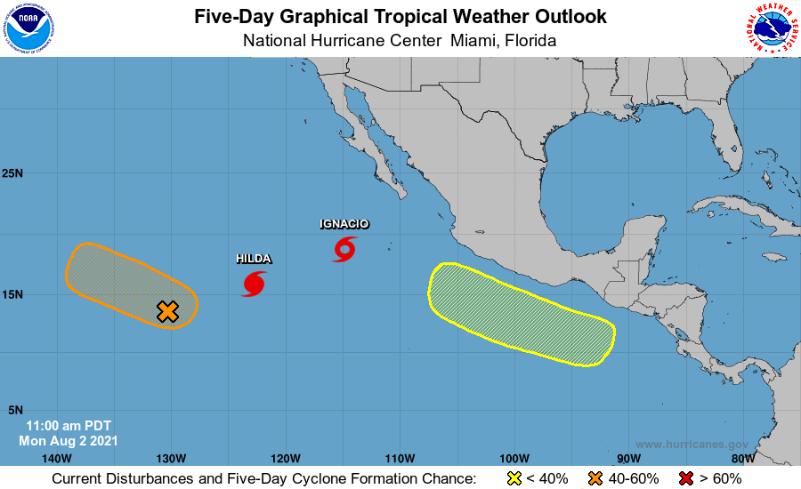
The same isn’t true in the Pacific where two named storms, one a hurricane, are spinning about while two suspect areas are being monitored for development.
The NHC is issuing advisories on Hurricane Hilda, located about 1,000 miles west-southwest of the southern tip of the Baja California peninsula, and on recently upgraded Tropical Storm Ignacio, located more than 400 miles southwest of the southern tip of the Baja California peninsula.
A low pressure system associated with the remnants of Tropical Depression 9-E is producing a large area of showers and thunderstorms more than 1,400 miles west-southwest of the southern tip of the Baja California peninsula. The NHC says that the shower activity has been increasing and showing some signs of organization over the past several hours, and environmental conditions are expected to be at least marginally conducive for a tropical depression to reform during the next day or so while the low moves west-northwestward to northwestward at 5 to 10 mph. The NHC says there’s a 60% chance that a tropical cyclone will re-form here.
The second area of concern is an area of low pressure that is expected to develop a few hundred miles south of the southern coast of Mexico by the end of the week. The NHC says environmental conditions are forecast to be conducive for gradual development thereafter while the system moves west-northwestward at 10 to 15 mph, just offshore and parallel to the coast of southwestern Mexico.
While moisture from these Pacific systems may eventually reach Hawaii, none of these systems are expected to impact any land mass as an organized tropical cyclone at this time.
