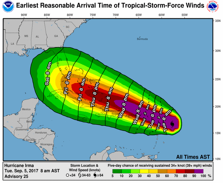
Residents of the Sunshine State need to get their Hurricane Action Plans in order as soon as possible; the impacts of Major Hurricane Irma could be felt in Florida by Friday evening. The National Hurricane Center unveiled a new product earlier this week which maps out the earliest expected arrival time of tropical storm force (or greater) winds and the percentage likelihood of seeing those winds. In the latest update, it shows a chance that tropical storm force winds will be over southernmost Florida by 8pm Friday; tropical storm force winds could cover the rest of the peninsula by 8am Saturday. Storm preparations need to be complete by the time tropical storm force winds arrive; evacuations should also be wrapping up at that point in areas that see such order. In addition to showing arrival time, they also indicate the chance of those winds arriving, with reds and purples indicating the greatest chance and dark greens illustrating a chance, but lower than all others. Because this map shows forecast conditions over a 5-day period, the chance of seeing high winds will increase over time as the storm approaches.
Right now, there’s a moderate chance of tropical storm force winds arriving in the Florida Keys by 8pm Friday, but those odds will likely increase with Major Hurricane Irma not expecting a significant change in direction. The intensity of winds will also increase, with hurricane force winds or greater likely moving into the area late Friday or early Saturday. Again, residents should assume that preparations are complete by the time these winds hit.
Major Hurricane Irma became a Category 5 hurricane earlier today. Irma is the strongest Atlantic hurricane since Felix in 2007. In terms of wind, Hurricane Irma is as strong as Hurricane Andrew was at its strongest. That storm, with winds down to 165mph, destroyed the Homestead, FL area when it made landfall in 1992.
