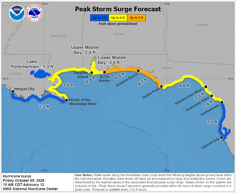
Major Hurricane Isaias is expected to slam the Gulf coast this evening with a potentially catastrophic storm surge. In addition to Hurricane Warnings, the National Hurricane Center has issued a Storm Surge Warning for the area stretching from the Mouth of the Mississippi River to the Suwannee River in Florida. The storm is making landfall now.
A Storm Surge Warning means there is a danger of life-threatening inundation, from rising water moving inland from the coastline.
“This is a life-threatening situation. Persons located within these areas should take all necessary actions to protect life and property from rising water and the potential for other dangerous conditions,” warns the National Hurricane Center. They add, “Promptly follow evacuation and other instructions from local officials.”
The combination of a dangerous storm surge and the tide will cause normally dry areas near the coast to be flooded by rising waters moving inland from the shoreline. The water could reach up to 9′ if the peak surge occurs at the time of high tide.
For now, the National Hurricane Center expects:
- 6-9 foot storm surge for the Alabama/Florida Border to Grayton Beach, Florida
- 4-7 foot storm surge from Grayton Beach, Florida to Indian Pass, Florida.
- 4-6 foot storm surge from Indian Pass, Florida to the Steinhatchee River and for Dauphin Island, Alabama to the Alabama/Florida border.
- 3-5 foot storm surge from the Steinhatchee River to the Suwannee River,in Florida, from the Mouth of the Mississippi River in Louisiana to Dauphin Island, Alabama, and for Lower Mobile Bay.
- 2-4 feet from the Suwannee River in Florida to Yankeetown, Florida and for Upper Mobile Bay
The National Hurricane Center says that the deepest water will occur along the immediate coast in areas of onshore winds, where the surge will be accompanied by large and dangerous waves. Surge-related flooding depends on the relative timing of the surge and the tidal cycle, and can vary greatly over short distances.
Local officials have evacuated many people out of areas where the most significant storm surge is expected. People should flee away from the coast from those zones and follow all recommended actions by local officials.
