• Skip to primary navigation
  • Skip to main content
  • Skip to primary sidebar

Weatherboy

Weatherboy Weather News, Maps, RADAR, Satellite, and Forecasts.

  • Local
  • Earth Science News
  • RADAR
  • Current Warnings
  • Satellite
  • Current Maps
  • Forecast Maps
  • Video

March to Kick Off with Mid Atlantic Snow

by Weatherboy Team Meteorologist - February 28, 2019

Light snow is likely across portions of Ohio, Pennsylvania, West Virginia, Maryland, New York, Delaware, Connecticut, and New Jersey. While generally 1-2" will fall some areas could see 3-4", as shown in the purple color.  Image: weatherboy.com
Light snow is likely across portions of Ohio, Pennsylvania, West Virginia, Maryland, New York, Delaware, Connecticut, and New Jersey. While generally 1-2″ will fall some areas could see 3-4″, as shown in the purple color. Image: weatherboy.com


While March 1 is the start to meteorological spring, it looks like Old Man Winter will be visiting those in the Mid Atlantic. Light snow is expected to spread in late Thursday into early Friday; while amounts will be light, the timing will make the morning commute tricky for many. And Old Man Winter may not be done: a more substantial storm could strike Monday in the same general area.

An approaching low is responsible for the snow. High pressure is building into New England today, keeping temperatures cold tonight. An area of low pressure will track across the DelMarVa Friday morning, then strengthen as it moves out to sea later Friday and Saturday.


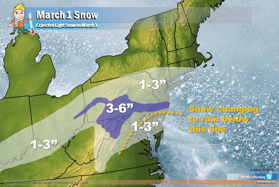
As this low forms and moves east, it’ll produce light snow across portions of the Mid Atlantic. Generally 1-2″ of snow is expected although some areas, especially in southern Pennsylvania and New Jersey, could see 3-4″. As milder air mixes in on Friday, some of the light snow will change to sleet and plain rain across extreme southern New Jersey, Delaware, and eastern Maryland.

A stronger low pressure system is forecast to track across portions of the Mid Atlantic Sunday into Monday before cold high pressure gradually builds toward the Mid Atlantic  Tuesday and Wednesday. That next system could produce significant snow along the I-95 corridor between Washington, DC and Boston, MA. However, it is too soon to say with certainty who will get snow and how much they’ll get.

Primary Sidebar

Sponsored Ad

Search

Latest News

  • Weak Morning Earthquake Rattles Maine
  • Nor’Easter Keeping Weather Cool and Damp in Northeast This Week
  • Miami’s National Hurricane Center Monitors Area for Cyclone Development
  • Scientists Unlock Climate Change Secrets: Say Ice Age Is Coming
  • Tornado Confirmed in New Jersey
  • National Hurricane Center Initiates Daily Reports Today
  • Severe Weather Likely Across Broad Area on Friday
  • Heat Blast Expected from Texas to Florida and from Minnesota to Arkansas
About | Careers | Contact | Contests
Terms | Privacy | Ad Choices
Weatherboy is a (R) Registered Trademark of isarithm LLC, All Rights Reserved.
All content herein is Copyright by Isarithm LLC 1997-2022