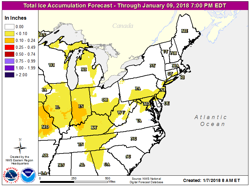
After digging out of a Blizzard to end the week last week, some in the Northeast will have to deal with something worse as they start the new week: an ice storm threat. While cold air will retreat, it will take time for cold air at and on the surface to moderate; the result will be precipitation falling in non-frozen form.
After a brutally cold weekend, high pressure will slowly move off shore setting the stage for the next Eastern weather maker. A southwesterly flow will increase through the night tonight in conjunction with a strengthening pressure gradient in between the retreating high and an upstream low pressure system over Ontario, Canada. On Monday and Monday Night, low pressure will pass south of James Bay on Monday with an attendant cold front crossing the Great Lakes region. A southwesterly flow will continue in the pre-frontal warm sector, bringing the threat of precipitation from southwest to northeast over the southeast, Ohio River Valley, and eventually the Mid Atlantic. While precipitation amounts look to be light, it appears precipitation will fall in this region as sleet or freezing rain, leading to ice accumulation over a potentially large area.
Worse, it appears that this icy problem will surface in time for the PM rush hour in eastern Pennsylvania and New Jersey, home to some of the busiest roadways in the nation. Long Island, New York can also see an icy situation forming during and after the PM rush time. Between 4pm and 7pm, freezing drizzle, freezing rain, sleet, and a mix of that ice with snow could fall on places like Philadelphia, Pennsylvania or anywhere on the New Jersey Turnpike or Garden State Parkway. The icy mix will freeze on contact with any untreated surface, making travel hazardous. Freezing rain and freezing drizzle can also accumulate on other surfaces that may be hard to treat, such as windshield wipers and automobile windows.
While the ice will be a light glaze at worse in the Mid Atlantic, more substantial accumulations of ice are possible across Missouri, Illinois, and Indiana. While it just takes a light glaze to make travel hazardous, additional accumulation could lead to power issues as the weight of ice snaps tree branches and wires.
By Tuesday, milder air will surge north, with precipitation ending from south to north, possibly as plain rain in southern locations. High pressure will return to the region, staying in place until the next winter storm threat arrives at the end of the week.