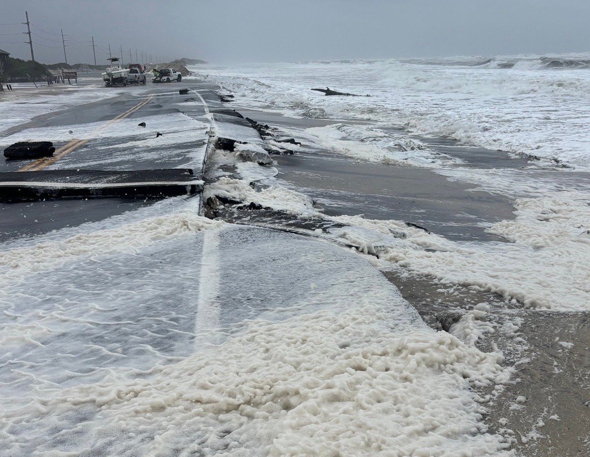
It appears the nor’easter forecast to impact the Mid Atlantic and southeastern New England over the next several days may be worse than initially expected, bringing a prolonged period of heavy rain, potentially damaging winds, rough surf and beach erosion, and more to the region. It is also possible the system could take on tropical or subtropical cyclone characteristics.
An upper-level trough digging into the eastern U.S. will interact with a cool air mass sliding east into the western Atlantic to develop a deep coastal cyclone just off the East Coast over the next few days. The cool air will be moistened and lifted by the digging upper trough as a large high pressure system feeds that cool air across the still warm waters of the western Atlantic. The result will be a rather strong cyclone that will bring widespread strong to gale-force winds up the East Coast of the U.S. through the next few days.
Considerable uncertainty remains regarding this cyclone’s track, but computer forecast models agree that the cyclone center will approach and then stall just off southeastern New England Friday and into the weekend.
Much of Friday could remain rain free along the East Coast but cool and damp northeasterly winds will continue to strengthen as the storm deepens offshore. Steady rain may hold off until Friday night across southeastern New England before spreading gradually westward into southern New England by Saturday morning. Additionally, expect wind gusts in excess of 45 mph, moderate to major coastal flooding, high surf, rip currents, and beach erosion.
It is possible this developing storm could take on tropical or subtropical cyclone characteristics as it develops east of New Jersey. Any transformation into such a weather system could make impacts worse.
Severe winds are expected, especially at coastal locations. Strong high pressure remains in place across eastern Canada, and it will hold fast through today before slowly weakening. Meanwhile, low pressure is organizing and strengthening well offshore of the North Carolina coast and it will further deepen and track northward through Saturday. The strengthening pressure gradient between the approaching low and high to the north will continue to result in persistent north to northeast winds across the Mid Atlantic and southeastern New England on Saturday, with the strongest expected along the immediate coast. Sustained winds will likely remain near 25-35 mph with gusts of 40-50 mph and even 60 mph at times in the coastal area. Inland winds will be gusty as well, mainly in the 20-30 mph range. Winds this strong could knock down tree limbs and interfere with electrical service. If the storm tracks a little more west than expected now, it could also bring 40-50 mph winds, which are tropical storm strength windspeeds, into the coastal plain along and south and east of I-95.
Heavy rain is expected to fall from this storm although the heaviest rain will be confined to the coast. Rainfall amounts range from 0.10-0.25″ in eastern Pennsylvania and central New York and interior New England to around 1-1.50″ along the northern New Jersey coast over the course of 48+ hours. 3-6″ of rain is expected across eastern Long Island and much of southeastern New England, with the heaviest rainfall amounts expected near Cape Cod.
Beyond rain water flooding with be multiple rounds of significant tidal flooding, prompting the National Weather Service to issue many Coastal Flood Warnings and Advisories for the Mid Atlantic and Northeast coasts. With a slow moving nor`easter and multiple days of strong northeast winds expected, the confidence in the threat for tidal flooding remains high. Strong onshore flow that has persisted for several days is resulting in water piling up across tidal tributaries and within back bays of coastal communities. Tidal levels will also be enhanced with astronomical tides increasing with the upcoming Full Moon tomorrow. This combination of factors will lead to widespread tidal flooding, some of which will get well into Moderate stage.
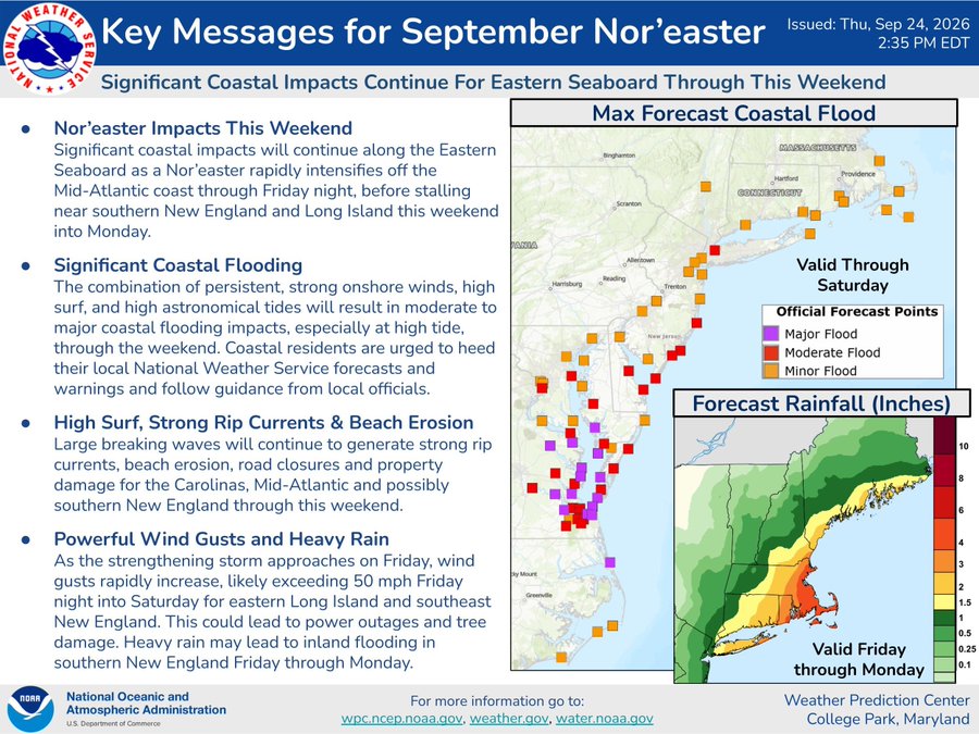
The National Weather Service warns, “While not currently forecast, the threat for Major flooding is not off the table, especially getting near the full moon. Guidance is starting to come into better focus regarding tidal levels. While oceanfront tide gauges have yet to reach moderate flood stage, back bay locations have. Expecting tide levels to continue to increase as we get closer to the Full Moon.”
Flooding will also become problematic for the tidal Delaware River.
For Delaware Bay communities, north/northeast winds will keep pushing water to the west side of the Bay and onto the Delaware coast. This will result in moderate tidal flooding around southern and central Delaware. Tide levels are high enough though on the New Jersey side of the Bay to result in minor tidal flooding, even with the wind pushing water away from the New Jersey’s Delaware Bay coastline.
Dangerous rip currents and high surf are expected at the Jersey Shore and Delaware Beaches through
Saturday, with more of the same expected across Long Island and southeastern New England. Beach erosion is likely and breaching of sand dunes is expected in many areas. Breaking waves within the surf zone of 6 to 12 feet are expected through Saturday. Dangerous rip currents will accompany the high surf, making it extremely dangerous to enter the water at any time through Saturday. The High Risk for life threatening rip currents remains in effect through Saturday for all beaches. A High Surf Advisory is in effect for all beaches through Saturday as well.
