• Skip to primary navigation
  • Skip to main content
  • Skip to primary sidebar

Weatherboy

Weatherboy Weather News, Maps, RADAR, Satellite, and Forecasts.

  • Local
  • Earth Science News
  • RADAR
  • Current Warnings
  • Satellite
  • Current Maps
  • Forecast Maps
  • Video

Severe Weather Likely in the East on Saturday

by Weatherboy Team Meteorologist - March 18, 2022

Severe weather is likely in the east tomorrow. While thunderstorms are possible in the light green area, severe thunderstorms are possible in the dark green and yellow areas with the greatest chance in the yellow zones. Image: weatherboy.com
Severe weather is likely in the east tomorrow, as the Convective Outlook from the Storm Prediction Center shows. While thunderstorms are possible in the light green area, severe thunderstorms are possible in the dark green and yellow areas with the greatest chance in the yellow zones. Image: weatherboy.com


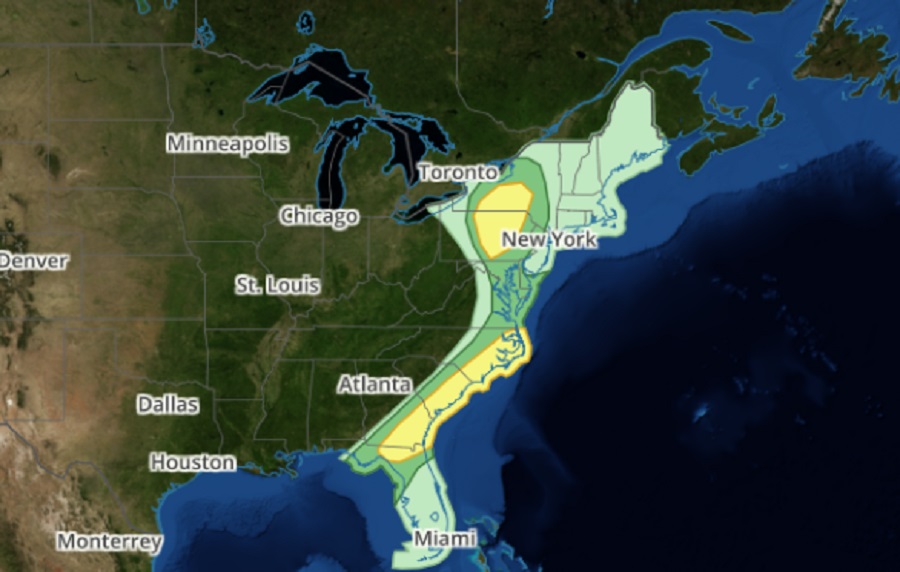
The National Weather Service’s Storm Prediction Center (SPC) is warning about the possibility of severe thunderstorms in the eastern United States on Saturday, with strong to severe storms likely in portions of New York, Pennsylvania, and the southeast coast from North Carolina to northern Florida. The greatest threat of severe weather will strike during the afternoon hours from late morning into early evening.

According to the SPC,  a shortwave mid-level shortwave trough embedded in a  larger-scale upper trough over the Midwest will lift northeast toward the Northeast on Saturday. A surface low will shift northeast along the lower Great Lakes and St. Lawrence Valley while a cold front will extend east across the Southeast/Mid-Atlantic. Isolated to widely-scattered thunderstorms will be possible from northern Florida and southeast Georgia into the eastern Carolinas ahead of the front through the afternoon. Further north across parts of Pennsylvania, New Jersey, and New York,  additional scattered storms are expected in the vicinity of the surface low and  surface front by late morning and shifting east and northeast through early evening.

Within these severe weather areas depicted in the SPC’s Convective Outlook, isolated tornadoes, wind damage, and large hail are possible.

Primary Sidebar

Sponsored Ad

Search

Latest News

  • Final Supermoon of 2025 Arrives
  • Geomagnetic Storm WARNING Issued for Earth; G3-STRONG Conditions Expected
  • Morning Shaking in Cooter Reminds of NMSZ Danger of Big Earthquakes Near Missouri
  • Two Earthquakes Strike New York Minutes Apart
  • Winter Storm to Dump A Foot or More of Snow in Northeast
  • Weak Earthquakes Rattle North Carolina and Tennessee Today
  • FAA Declares Emergency Order; Grounds Jets From Multiple Airlines due to Geomagnetic Storm Threat
  • Significant Winter Storm Likely in Northeast Tuesday-Wednesday
About | Careers | Contact | Contests
Terms | Privacy | Ad Choices
Weatherboy is a (R) Registered Trademark of isarithm LLC, All Rights Reserved.
All content herein is Copyright by Isarithm LLC 1997-2022

Insert/edit link

Enter the destination URL

Or link to existing content

    No search term specified. Showing recent items. Search or use up and down arrow keys to select an item.