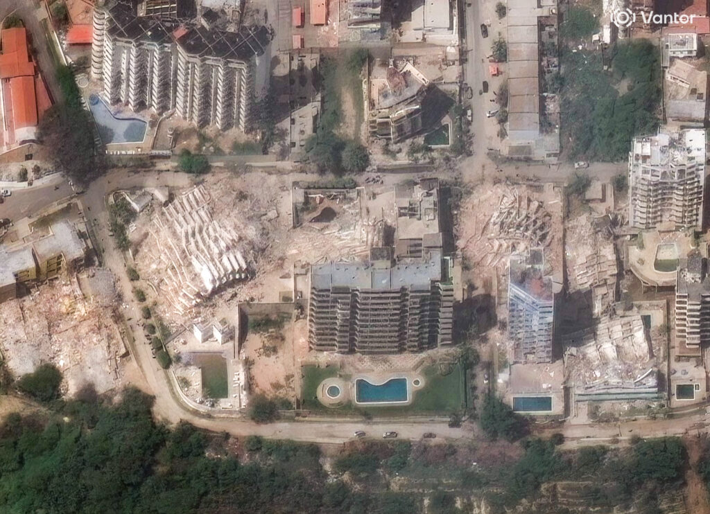
While the official death toll continues to climb steadily, USGS is warning the loss of life and property may be extreme due to the pair of earthquakes which struck Venezuela earlier this week.
On Wednesday evening, June 24, 2026, Venezuela was struck by a catastrophic “doublet” earthquake sequence consisting of a magnitude 7.2 and 7.5 event, making it the most powerful seismic event to hit the country in over 125 years. The back-to-back tremors occurred just 39 seconds apart along the complex Caribbean plate boundary of northern Venezuela, inflicting severe structural collapse across the capital city of Caracas and surrounding coastal regions.
As of the publication of this article, government officials have confirmed at least 920 deaths, over 3,300 injuries, and more than 50,000 people missing. But USGS warns the toll may go much higher than that. USGS says there’s a 65% chance that the death toll will be 10,000-100,000 or more based on the intensity of the shaking that occurred. USGS also estimates that economic losses of 2-10% of GDP of Venezuela will also be attributed to the earthquakes.
Absolute devestation! https://t.co/y6AnxzImd0
— the Weatherboy (@theWeatherboy) June 26, 2026
La Guaira, a coastal state north of Caracas, is where some of the worst destruction has occurred. Over 100 high-rise apartments and hotels in the area completely “pancaked,” trapping hundreds of families. Other heavily hit states include Yaracuy, the Capital District of Caracas, Miranda, Aragua, Carabobo, and Falcón.
Satellite imaging company Vantor is sharing high-resolution photography of the disaster zones. Vantor has activated its Open Data Program for Venezuela in response to yesterday’s powerful earthquakes, providing frontline organizations and the open source mapping community with free access to our high-resolution imagery to help accelerate response and recovery efforts. On X, they wrote, “We will be continuously uploading new high-resolution satellite imagery to this site in the coming hours and days as soon as it becomes available. All imagery is provided under a non-commercial Creative Commons 4.0 license (CC BY-NC 4.0). This imagery can be used to identify damaged infrastructure, map changes on the ground and prioritize the areas most in need of support, helping ensure resources are allocated quickly and effectively.” The website is https://vantor.com/company/open-data-program/ .
Huge response from the U.S. and other countries around the world to help Venezuela’s earthquake search/rescue/recovery missions: https://t.co/4aCLwTVFPL
— the Weatherboy (@theWeatherboy) June 26, 2026
Very, very sad. https://t.co/J7DW1zIEpf
— the Weatherboy (@theWeatherboy) June 25, 2026
Incredible destruction across the coast of Venezuela from yesterday’s two powerful earthquakes: https://t.co/qG0gfha0id
— the Weatherboy (@theWeatherboy) June 25, 2026
DD
