• Skip to primary navigation
  • Skip to main content
  • Skip to primary sidebar

Weatherboy

Weatherboy Weather News, Maps, RADAR, Satellite, and Forecasts.

  • Local
  • Earth Science News
  • RADAR
  • Current Warnings
  • Satellite
  • Current Maps
  • Forecast Maps
  • Video

Persistent Severe Weather Threat to Linger to Friday

by Weatherboy Team Meteorologist - September 2, 2026

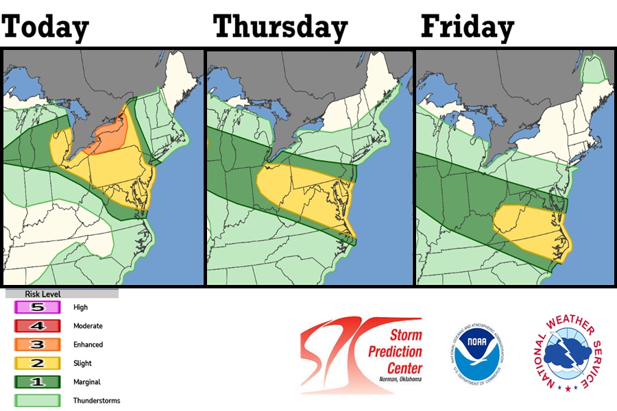
Yellow and orange areas are at higher risk of seeing severe weather today, tomorrow, and Friday. The severe weather threat should wrap up for these areas this weekend. Image: NWS SPC

After a day of violent thunderstorms and numerous Tornado Warnings yesterday, there is still a lot of severe weather persisting over portions of the eastern Great Lakes, Northeast, and Mid Atlantic. Yesterday much of the severe activity impacted Pennsylvania and New Jersey; today it has shifted back to Pennsylvania and New York. Tomorrow it will shift south somewhat to an area stretching from Ohio to Delaware, Maryland, and Virginia. On Friday, the threat zone shifts to West Virginia, Virginia, and northeastern North Carolina.

Scattered to numerous severe thunderstorms are likely across parts of the Great Lakes to the Mid-Atlantic  through tonight. Damaging winds are the main threat, though some large hail
and a few tornadoes may also occur.

An active frontal zone extends from the northern Plains and Upper Midwest into the Great Lakes and Northeast. Shortwave energy ejecting from the upper trough will interact with this boundary, while warm moist air moves northward. This setup will lead to periods of showers and thunderstorms. The strongest storms will bring moments of heavy rainfall, severe thunderstorms, hail, damaging winds, and flash flooding risk across portions of the Upper Midwest and Mid-Atlantic into the Northeast into early Friday morning.

The upper ridge over south-central U.S. will maintain dangerous heat across much of central and eastern U.S. through Friday. Daytime highs will reach between 95-105 degrees across the central and southern Plains, Midwest, Mid-Atlantic, and Southeast. The combination of above normal temperatures and high humidity will result in widespread Major to Extreme HeatRisk, which may bring heat-related illnesses.

Primary Sidebar

Sponsored Ad

Search

Latest News

  • Persistent Severe Weather Threat to Linger to Friday
  • Tropical Storm Edouard Strikes Louisiana; Brings Bad Floods to Texas Today
  • Three Storms to Dance Around Hawaii; Will One Hit?
  • Multi-Day Tornado Threat for New Jersey & Surrounding Areas
  • Texas & Louisiana Brace for Compact Storm; Warnings Issued
  • Authorities Urge Caution & Preparation As New Tropical Threats Approach Hawaii
  • Tropical Storm Brewing in Gulf Could Soon Strike Texas
  • Tropical Storm Dolly Forms Day After Dolly Parton Death
About | Careers | Contact | Contests
Terms | Privacy | Ad Choices
Weatherboy is a (R) Registered Trademark of isarithm LLC, All Rights Reserved.
All content herein is Copyright by Isarithm LLC 1997-2022

Insert/edit link

Enter the destination URL

Or link to existing content

    No search term specified. Showing recent items. Search or use up and down arrow keys to select an item.