• Skip to primary navigation
  • Skip to main content
  • Skip to primary sidebar

Weatherboy

Weatherboy Weather News, Maps, RADAR, Satellite, and Forecasts.

  • Local
  • Earth Science News
  • RADAR
  • Current Warnings
  • Satellite
  • Current Maps
  • Forecast Maps
  • Video

National Hurricane Center

Hurricane Dora Picks Up Strength; Indirect Impacts to Hawaii Likely

by Weatherboy Team Meteorologist - August 2, 2023

This colorized satellite photograph of circled Hurricane Dora shows warmer sea surface temperatures in oranges and reds and colder sea surface temperatures in blues and greens. Image: NOAA

[…]

Tropical Storm Don Forecast to Dissipate After Wild Track

by Weatherboy Team Meteorologist - July 23, 2023

This map shows where Don has been this month and includes the forecast cone of where it should go as it continues to weaken and fade away. Image: NHC

[…]

Hurricane Don Forms in Atlantic; Additional System Possible

by Weatherboy Team Meteorologist - July 22, 2023

Hurricane Don is clearly visible on this GOES-East satellite view where it is spinning about well east of the Northeastern U.S. coast. Image: NOAA

[…]

Hurricane Center Expects New System to Develop in Atlantic

by Weatherboy Team Meteorologist - July 21, 2023

This satellite view from GOES-East, which also includes a colored sea surface reflecting warmer (red) and colder (green) waters, has a new disturbance circled that is expected to become the Atlantic Hurricane Season's next tropical cyclone. Image: NOAA

[…]

Tropical Storm Don Being Monitored Along with One New Possible System

by Weatherboy Team Meteorologist - July 20, 2023

In addition to Tropical Storm Don, the National Hurricane Center has also highlighted another region in the Atlantic that could create a new tropical cyclone in the coming days. Image: NHC

[…]

Tropical Storm Don Moving Over Warmer Waters; Forecast to Strengthen

by Weatherboy Team Meteorologist - July 19, 2023

This view of Tropical Storm Don over the Atlantic from the GOES-East satellite combines a standard satellite picture with a map reflecting current sea surface temperatures, with reds and oranges warm and greens and blues cold. Image: NOAA

[…]

Tropical Storm Watches Could Be Issued Tonight for Hawaii as Calvin Heads to the Aloha State

by Weatherboy Team Meteorologist - July 16, 2023

Current GOES-West satellite view shows Hawaii to the left and Tropical Storm Calvin on the right approaching Hawaii. Image: NOAA

[…]

Calvin Likely to Strike Hawaii’s Big Island Tuesday Night

by Weatherboy Team Meteorologist - July 15, 2023

This map generated by data and imagery collected by the GOES-West satellite shows water temperatures, with cooler waters represented by blues and greens and warmer waters represented by oranges and reds. The more blue it is the colder it is while the more warmer it is, the more red it is. Hurricane Calvin is moving in the direction of Hawaii, but to do so, it'll be traveling from an area with warm water ripe for intensification into an area with cooler weather good for weakening. Image: NOAA

[…]

NOAA Unveils New Hurricane Computer Forecast Model

by Weatherboy Team Meteorologist - July 14, 2023

The Hurricane Analysis and Forecast System (HAFS) “moving nest" Model. Global map showcasing land mass in green and water in black, clouds in white and tropical storms outlined in a green boxes representing the moving nest model. Image: NOAA

[…]

Subtropical Storm Don Spins in Atlantic Ocean
by Weatherboy Team Meteorologist - July 14, 2023

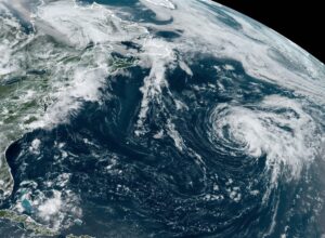
Subtropical Don spins about in the open waters of the central North Atlantic as this image from the GOES-East weather satellite shows. Image: NOAA

[…]

Hurricane Calvin Becomes Major Hurricane; Impacts to Hawaii Likely Next Week
by Weatherboy Team Meteorologist - July 14, 2023

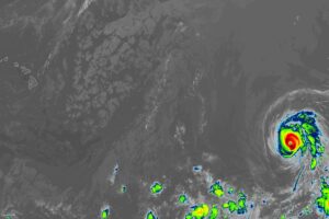
Hawaii on the left may encounter a rendezvous with Major Hurricane Calvin on the right early next week. Calvin is expected to weaken significantly before impact though. Image: NOAA

[…]

Hurricane Calvin Gains Strength; Heads in Hawaii’s Direction

by Weatherboy Team Meteorologist - July 13, 2023

The current view of the Pacific Ocean from the GOES-West weather satellite shows a well defined hurricane between Hawaii and the North American west coast. Image: NOAA

[…]

Tropical Storm Calvin Could Impact Hawaii Next Week

by Weatherboy Team Meteorologist - July 12, 2023

Current National Hurricane Center forecast for Calvin shows the storm intensifying to hurricane status before weakening back to tropical storm status as it heads in the general direction of Hawaii. Image: NHC

[…]

Tropical Atlantic Quiets while Eastern Pacific Gets Busy

by Weatherboy Team Meteorologist - July 1, 2023

The red circle is around Tropical Storm Adrian and the orange circle is around of what's left of Beatriz; both were hurricanes at some point. The National Hurricane Center is also monitoring another area, around the yellow circle, for possible tropical cyclone development over the next week. Image: NHC

[…]

Cindy Could Regenerate and Hit North America

by Weatherboy Team Meteorologist - June 26, 2023

Today's Tropical Outlook shows the area where Cindy may regenerate this week. Image: NHC

[…]

Tropical Storm Cindy Forecast to Fall Apart, But Surprise Ending Possible for Maine / Canada

by Weatherboy Team Meteorologist - June 25, 2023

The eye is drawn to Tropical Storm Cindy on this latest GOES-East weather satellite view of the western Atlantic. Image: NOAA

[…]

  • « Go to Previous Page
  • Go to page 1
  • Interim pages omitted …
  • Go to page 17
  • Go to page 18
  • Go to page 19
  • Go to page 20
  • Go to page 21
  • Interim pages omitted …
  • Go to page 34
  • Go to Next Page »

Primary Sidebar

Sponsored Ad

Search

Latest News

  • New Tropical Cyclone Could Form by Hawaii
  • Heavy Rain Threatens Flash Flooding in South Florida Days after Record King Tide Swamped the Coast
  • Severe Storms and Tornado Threat to Sweep From New Mexico into the Southern Plains Sunday Night and Monday
  • Rare Autumn Atmospheric River Drenches Arizona and Southern Utah, Raising Flash Flood Threat on Saturated Ground
  • FEMA Uses Halloween to Warn Americans to Prepare For Emergency or Disaster
  • Halloween Storm Brings Season’s Heaviest Snow Yet to Sierra Nevada Peaks
  • King Tide Flooding Lingers in Florida Keys and Along Atlantic Coast as Heavy Rain Looms
  • Atmospheric River Takes Aim at Waterlogged Arizona after Friday Flash Floods
About | Careers | Contact | Contests
Terms | Privacy | Ad Choices
Weatherboy is a (R) Registered Trademark of isarithm LLC, All Rights Reserved.
All content herein is Copyright by Isarithm LLC 1997-2022

Insert/edit link

Enter the destination URL

Or link to existing content

    No search term specified. Showing recent items. Search or use up and down arrow keys to select an item.